 Malgomaj is regulated within these levels:
Lowest 337,0 meters above sea level and highest 343,5.
The diffenrence in level is 6,5 meters.

History:
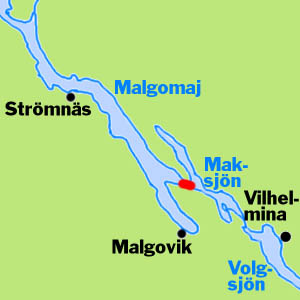
The people living all around Lake Malgomaj wanted a better way of getting to the main village Vilhemina by Lake Volg. The best way of transportation in this area was by boat in summertime and by slades on the ice during winters. To make these transports better they wanted canals between Lake Malgomaj and Lake Mak and between Lake Mak and Lake Volg.
Between Lake Malgomaj and Lake Mak there was a very little difference in elevation so no lock would be necessary, Between Lake Mak and Lake Volg the difference in elevation was 6,6 meters so a canal here would need locks.
In 1897 the engineer Hjalmar Bergman worked out a plan for these canals and found that it would cost 223 600 SEK in total.
In 1902 county governor Cederberg in Umeå was called on with a petition for money for this project. He promised 19 200 SEK which would be enough for a canal between Lake Malgomaj and Lake Mak. The works started in 1903.
The fairway was totaly 60 kilometer long and 1,3 kilometer was canalized. The depth in the canal depended on the general level of water in the lakes, which varied much, both seasonally and from year to year. 1.0 meter was the lowest depth and 1.5 meter the most common during summertime. The canal connected Lake Malgomaj with Lake Varris and Lake Mak. The captain of the steamer had to mark the fairway by himself.
The new canal was finished in 1907 at a cost of 27 652:43 SEK. From the authorities they got 19 200 SEK and the rest was paid privately by the legendary Lundberg brothers. These maintained a vast traffic with steamers on the lakes in the area. They also had sawmills and other businesses.
The lakes in the area were regulated during the 1950ies. This made the canal too shallow and a new one was dredged by the electrical dredger Marion. The new canal mainly follows the old one, but makes a new way into Lake Varrisen and to Lillstrucken and Lake Mak.
Old experienced boatowners with shallow boats still prefer the old canal.
 Malgomaj is regulated within these levels:
Lowest 337,0 meters above sea level and highest 343,5.
The diffenrence in level is 6,5 meters.
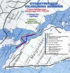
The chart at right covers the lakes Malgomaj, Varisen and Maksjön
and is made by Lars-Erik Holmgren for Skansholmen Boat Club.
Here we show only the part with Storstrucken and Lillstrucken.
Click on it to see it in greater scale.
A hundred years old remnants | From the late spring | Moody picture from Malgomaj |
© Pictures by Lars-Erik Holmgren, Vilhelmina
The old canal | View towards souhtwest from the northern part of the canal |
© Pictures by Lars-Erik Holmgren, Vilhelmina. February 2003
View towards souhteast from the northern part of the canal | View towards souhtwest from the northern part of the canal |
© Pictures by Lars-Erik Holmgren, Vilhelmina. February 2003
From the northern part of the canal
© Picture by |
This page was modified at